Showing posts with label Cruising -- Bahamas. Show all posts

Monday, February 20, 2017

The Long Haul


Atlantis Resort, Nassau
We woke up at midnight on January 26th with "Little Lara" hobby-horsing as the waves surged into the anchorage at Shroud Cay.  The wind had shifted during the night and increased to 10-15 knots, leaving the boat exposed to the wind and waves.  By 3:00 am the anchorage was so uncomfortable, we decided to leave for Nassau. As we traveled through the night, the stars were out in their abundance, as there was no moon. It was a beautiful night. By sunrise we were sailing under main and jib as we crossed Yellow Bank.  This is an area of shallow water with many uncharted coral heads.  As we sailed along, we could clearly see the ocean bottom as it reached up from 8-12 feet.  We arrived safely in Nassau where we stayed one night at the Palm Cay Marina.  Here we bought provisions, filled our water tank and topped off with diesel.  Leaving the marina we cut through Nassau Harbor, after obtaining permission to do so from Harbor Patrol, as we continued our northward voyage.  The harbor is congested with water taxis, fishing boats and cruise ships.  We were no longer in the quiet out islands, but back in civilization with its luxury homes, high-rise apartments and five star hotels.

Bird Cay, Berry Islands
From Nassau we sailed to the Berry Islands, anchoring off Bird Cay.  We were excited to be away from the noise and congestion of Nassau, and we found Bird Cay to be a haven of beauty and tranquility.  This 250 acre Tropical Island is located at the south end of the Berry Island chain. It is well protected on all sides by sand banks and islands with fun names like Cat Cay, Whale Cay,  Crab Cay and Chub Cay.  Bird Cay was recently listed for sale and can be purchased for a mere $8,900,000, if you are interested.

Berry Island Club
The next morning we learned that another winter storm was headed our direction, so we decided to move "Little Lara" to Chub Cay where we hoped to gain more all around weather protection.  Marine life around Chub Cay is prolific with an abundance of coral reefs, billfish, bonefish, turtles, lobster and conch in the waters surrounding the island. This entire area is within the Southern Berry Islands Marine Reserve.  We anchored off Berry Island Club, which was closed for renovations and repairs due to Hurricane Mitchell.  Never-the-less, we enjoyed exploring the island, walking the roads, and visiting nearby Cat Cay.

We were blessed, experiencing none of the projected high wind and seas, so we decided to leave the Berry Islands on January 31st for Florida.  The revised forecast was calling for light winds and calm seas, a perfect opportunity to make the 135 mile overnight trip.  But, before reaching Fort Lauderdale, we would have to cross the Tongue of the Ocean and the Gulf Stream.

Tongue of the Ocean and Andros Island

The Tongue of the Ocean is a U-shaped, relatively flat-bottomed trench approximately 20 miles wide by 150 miles long. Its depth varies gradually from 3,600 feet in the south to 6,600 feet in the north.  It is one of the world’s deepest undersea canyons in the world. It lies between Andros Island and New Providence Island.

Gulf Stream
(In Red)

The Gulf Stream, on the other hand, is a powerful, warm, and swift Atlantic ocean current that originates in the Gulf of Mexico and stretches around the tip of Florida, and follows the eastern coastlines of the United States before crossing the Atlantic Ocean.  The velocity of the Gulf Stream current is fastest near the surface, with the maximum speed of 5.6 miles per hour and an overall average speed of  four miles per hour. The Gulf Stream transports nearly four billion cubic feet of water per second, an amount greater than that carried by all of the world's rivers combined. This means we could not sail "Little Lara" straight to Florida, but would have to head southward as the currents pushed us northward, leaving an elongated "S" shaped track as we crossed this body of water.

"Little Lara's" 135 mile track from Chub Cay to Fort Lauderdale

"Little Lara" 
ready for shipment to California
As we sailed through another moonless night, we found comfort in the loom of Fort Lauderdale's night lights as they lit up the horizon, which we could see from 40 miles away. We arrived in Florida on February 1st after a 27 hour passage. Shortly thereafter, we loaded "Little Lara" on a transport for the 3500 mile trip back to California where she will once again be sailing in the waters of San Francisco Bay.  Thus, our Bahama adventure comes to an end.  What memories!  What friends!  We hope all your memories are as wonderful regardless of where your travels take you.  And, may you too find fair winds.

Visiting family in Utah

Saturday, February 4, 2017

Up A Creek

Shroud Cay, Exumas

We continued making our way northward eventually anchoring at Shroud Cay.  This island is noted for its extensive network of mangrove creeks that crisscross its interior.  We explored the northernmost creek, which winds its way eastward, where the water becomes deeper, and then finally empties into the ocean.  Here we found a beautiful little white sandy beach where we beached the dinghy, and walked around the corner and up the hill to experience Camp Driftwood.  


Finest white sand, and turquoise blue ocean, and crystal clear water.
Notice the creek on the right emptying into the ocean on the left.

View from Camp Driftwood looking out to Sea


Beaching the Dinghy
Apparently Camp Driftwood has been on Shroud Cay since the 1960’s, when a sailing hermit named Ernest Scholtes stayed on his boat in the anchorage and built a cozy place on the ridge line, little by little, with pieces of driftwood, shells, sea beans, floats and colorful bits found on the beach. He carved steps into a steep rocky slope on the ocean side, cleared away brush and carried sand up the slope in sail bags for the trail. Years later, the U.S. DEA had a camera set up here to spy on Carlos Lehder’s activity on nearby Norman’s Cay. Carlos Lehder was a co-founder of the Medellin Cartel and a former Colombian drug lord. He is currently imprisoned in the United States. Born in Armenia, Colombia, Lehder eventually ran a cocaine transport empire on Norman's Cay that reached into the billions of dollars.  


Mangrove Creek


Site of former Camp Driftwood

Enjoying the view
When we arrived at Camp Driftwood we found the carved steps and the sand cover trails, but there was no driftwood, shells, sea beans, floats or DEA cameras. The beach, however, at the foot of Camp Driftwood is one of the most beautiful we've ever seen, with the finest white sand, and turquoise blue ocean, and crystal clear water.  The sand flats reach out seaward from the island for miles and shimmer in the sunlight when covered by the turquoise waters at high tide. The current in this area is swift and, at times, the water rippled inexplicably. We spent the day enjoying the beach, and hiking the trail up to the Camp Driftwood site, and floating the creek discovering something new around every bend. 


It was another one of those magical moments in the islands and Peggy has proclaimed Shroud Cay her all time favorite place in the Bahamas.  May you too have magical moments in your life along with fair winds.

Saying goodbye to the Exumas...

Thursday, February 2, 2017

Under The Sea


On January 16th we began our journey north in anticipation of crossing back to Florida in February. We were determined on our way northward to stop at all of the anchorages along the way we had missed because of storms.  The first anchorage we arrived at was Pipe Cay and the abandoned Decca
Abandoned Decca Station
Station. The Decca Navigator System was a hyperbolic radio navigation system which allowed ships and aircraft to determine their position by receiving radio signals from fixed navigational beacons. The system was invented in the US, but development was carried out by Decca in the UK during WWII. After the war it was extensively developed around the UK and later used in many areas around the world. Decca's primary use was for ship navigation in coastal waters, offering much better accuracy than the competing LORAN system. Fishing vessels were major post-war users, but it was also used by aircraft.  Decca was eventually replaced, along with Loran and other similar systems, by the GPS during the 1990s.


Decca Station Port Captain


Exploring Compass Cay 

From Pipe Cay we sailed further north to Compass Cay. There we went ashore to enjoy Compass Cay Marina and to walk the trails around the island. Compass Cay Marina is know for nurse sharks. These sharks are bottom feeders appearing to sit on the bottom of the shallows and suck sediment and little critters from the sand. Since the marina workers feed the fish, this makes the nurse sharks very friendly; they’re not likely to expend the extra effort to gnaw off an arm or a leg when they know that they’re going to get something much better hand-fed to them. 


Nurse Shark


Compass Cay Shoreline


Chicken Cay Plane Wreck
From Compass Cay we traveled to Chicken Cay (Fowl Cay).  Anchoring off this private island we observed a wrecked airplane up on the beach which appeared curious and would have been fun to explore had we been able to go ashore. Anchoring at Chicken Cay put us close to Rocky Dundas, a short dinghy ride away. Rocky Dundas consists of two high and forbidding cays on the southern end of the Exuma Cay Sea and Land Park. Two partially submerged caves located on the cays have stalactite and stalagmite formations seen nowhere else in the Bahamas.  Legend has it that Rocky Dundas was a sacred site for the Lucayans Indians.  Because it was high tide when we arrived there and there was a swell running, we were unable to enter the caves. Disappointed, we made plans to return another day.


Peggy Swimming at the
Sea Aquarium with Mary Beth

Because there was once again a northerner coming our way, we decided it best to seek a safe anchorage with north and west wind protection.  So we sailed to Bell Island, just east of Cambridge Cay.  Here we felt we would be able to explore the surrounding islands before the winter storm arrived with David and Mary Beth aboard s/v "Regina Maris".  We enjoyed snorkeling the "Sea Aquarium", Pasture Cay and Cairns Garden.  The Sea Aquarium, an appropriately named snorkeling site, has an amazing variety of fish in a sheltered cove off north O'Brien Cay.  Pasture Cay is a triangular shaped reef set in 25 feet of water, with the the remains of a sunken light plane from the 1980s. The Cairn Garden is a convenient shallow area of soft corals located just west of the cairns off Cambridge Cay.  We enjoyed this protected area so much, we ended up staying here a week, though the predicted storm proved to be much milder than originally forecast.  

Sunken Plane Wreck at Pasture Cay

As promised, we eventually were able to return to Rocky Dundas were we snorkeled the two submerged caves. These grottos rivaled Thunderball Grotto we had snorkeled earlier at Staniel Cay.  We were dazzled by the rich colors and the stalactite and stalagmite formations.  We especially enjoyed our new found friends David and Mary Beth.

Mary Beth and Peggy enjoying
Rocky Dundas' Caves

Rocky Dundas' Stalactite and
Stalagmite Formations

Until we meet again, fair winds!

Thursday, January 26, 2017

See What You Sea

Black Point Anchorage

You will recall, a massive winter storm crisscrossed the United States the week of January 6, 2017 dropping 15-20 inches of rain and snow in its wake. This storm caused flooding and power outages, while blocking roadways and stalling traffic all up and down the East coast. The storm eventually passed offshore, only to arrive here in the Bahamas.  Though we did not experience the rains and snow levels like they did in the States, we did receive gale force winds of 30-35 knots. Having waited at Staniel Cay nine days for this storm to pass, and the winds and waves to subside, we finally decided to sail 16 miles south to Black Point Settlement on Great Guana Cay. Our original plans were to head north from Staniel Cay, but the forecast called for several more days of high winds. We had already spent three days confined aboard "Little Lara" and we were more than anxious to get ashore. Black Point Settlement provided us that opportunity.  The settlement at Black Point is a gem! It has a great harbor with plenty of room in the anchorage. But, the most attractive thing about this area is the people - friendly, outgoing, and focused on being of service to cruisers. We also enjoyed the white sandy beaches with their rocky cliffs and blow holes as we waited for the storm to pass.  This week we are expecting light winds which will be great for heading north to see all the wonderful islands that we missed on the trip down. We plan to travel to Nassau, the Berry Islands, Bimini and then back to Florida in February. Again, we hope you enjoy the pictures and video.


Waves crashing on shore


We found a lot of sea glass on this beach


This arch is underwater at high tide


One of the shells I found here


Monday, January 16, 2017

When Pigs Swim, You Say!

Another Beautiful Bahamian Sunset

We spent a week enjoying the Exuma Cays Sea and Land Park before we left for Staniel Cay.  Staniel Cay lies about 25 miles south of Warderwick Wells.  The island is approximately two square miles. Staniel Cay has a small Bahamian village on the western shore with a population of less than 110. The village is composed of homes, a church, a post office, a library, three small retail stores and marine supply shops.  The population caters primarily to tourists.  This area is primarily known for Thunderball Grotto, swimming pigs and pristine beaches.

Thunderball Grotto

Thunderball Grotto Sea-life
Inside Thunderball Grotto
In 1965, Thunderball Grotto, a limestone cave situated on the western coast of Staniel Cay, was the setting of the James Bond film "Thunderball". It was from this film the name Thunderball was given to the grotto. The island was also used as a filming location for a scene in the (1983) James Bond movie "Never Say Never Again".  Thunderball grotto, which is a natural limestone cavern that can be entered from underwater. Light enters through a vaulted ceiling and a variety of sea-life swim in the water inside the cavern, including the purple parrotfish, yellowtail snappers, angelfish and sergeant majors.  While at Staniel Cay we took an opportunity to snorkel the grotto.  It was eerie swimming underwater to enter one of the openings and gain access to the interior of the cavern. Once inside we found the sea-life to be amazing and the light bouncing of the cavern walls extraordinarily beautiful.  Coming from above and filtering through the watery openings from below, the sun light rays appear blue, turquoise, pink and green.  We spent about an hour inside the grotto feeding the fish corn and exploring all of the cracks, crevices and openings.   

The Famous Swimming Pigs

We were anchored at Big Major Cay during our stay at Staniel Cay, an uninhabited island a short dinghy ride away from Staniel Cay . This is the home of the famous Bahama Swimming Pigs.  There are approximately 20 pigs and piglets on Big Major Cay. They are not native to the island and popular lore suggests that they were dropped off by a group of sailors who planned to return and cook them, or that there was a nearby shipwreck and the pigs swam to shore.


Pig Beach

Personally, we believe they were left here in more recent times by local Bahamians tourist guides who wanted to bring visitors to the island to feed them. What a sweet deal!  Think about it, because the pigs live on the island where there is plenty of fresh water and they are constantly fed by tourists, the owners can come back during the holiday season and pick out a nice fat free pig when they are planning a pig roast for friends and family.  We were told that some of the pigs in fact do periodically disappear, but it is claimed they are stolen by other Bahamians for relocation to other islands to similarly attract tourists to those areas. After all, we were informed, these are special "swimming pigs" and pigs do not swim naturally! They must be bred to do so. Thus, you can not just drop off any old domestic pig on an uninhabited island and expect them to swim out and greet tourists for a free meal. But, we think pigs are pretty smart animals and if they are hungry...  well you decide which story you like best.


Pirate's Beach

We also enjoyed the novelty of "Pirate's Beach".  While at Big Majors Cay we were anchored just off this beach. There we spent numerous hours looking at the many interesting items left behind by passing cruisers. In the picture above, hopefully you will be able to identify not only the chairs, tables, signs, and flags, but also the skulls and cross bones.


Our anchorage at Big Major
The calm before the storm!

We stayed nine days in the Staniel Cay area waiting for weather to go north.  A good sailing day never presented itself, so we decided to head south instead, but that is a topic for a future blog.  Until then, we hope you have fair winds and calm seas.

Check out those storm clouds!


Fair Winds

Saturday, January 14, 2017

Exuma Cays Land and Sea Park


We left Rock Sound, Eleuthra on December 28, 2016 to sail the 45 miles to Warderwick Wells, Exuma.  Here lies the Exuma Cays Land and Sea Park.  Since we began planning our trip to the Bahamas last year the park has been one of our "must see" destinations.  The park is considered to be the most pristine and possibly the most beautiful area in all of the Exumas.  On the north end of the island is the 70 foot high Boo Boo Hill and on the southern end is Pirate's Lair.   Boo Boo Hill is where cruiser leave driftwood plaques carved with their boat name.

Cruiser's Driftwood Plaques

Can You Spot "Little Lara's" Plaque?

Boo Boo Hill is said to be haunted and late, on overcast nights, when the moon is full, you can hear a congregation of missionaries singing hymns.  These early English missionaries were shipwrecked on the island and eventually perished. Also, nearby are blowholes from which seawater shoots up high into the air with an eerie "whooshing sound", when the wind and waves are just right.

Pirate's Lair

Pirate's Lair lies a short walk inland down a conch shell lined path with palm trees on either side.  At the end of the path is a small opening with a fresh water well off to one side.   It is rumored that in this area pirates would gather when they came ashore to discuss pillaging  and plundering and do whatever pirates in the 1700's did on their days off.

Warderwick Wells North Anchorage
Are you able to identify "Little Lara"?

Designated as a replenishment area (this means no taking of plants, animals or marine life)  Exuma Cay Land and Sea Park encompasses 15 major cays over 176 square miles.  You can only get here by boat. The best way for us to describe the week we spent in the park hiking, snorkeling and exploring is through pictures. Enjoy!

Whale Bones' Display


Peggy claiming the trail to Beryl's Beach

Snorkeling off Warderwick Wells

Wow, is that a Mermaid?

Do you see the fish hiding in the sponge?

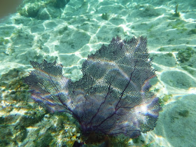
Cool purple Sea Fan