Sunday, December 25, 2016

Its Christmas Time in the Bahamas

A Bahamian Nativity Scene

Christmas in the Bahamas feels different to us this year.  While our kids send us pictures of Christmas trees and gently falling snow, we are experiencing 80 degree weather (coupled with 80% humidity),
"Little Lara's"
Christmas Wreath

sunny skies and brilliant turquoise
Main Street
Green Turtle Cay
waters. To make it feel more like Christmas Peggy decorated "Little Lara" with a handmade wreath adding sea shells and pine cones for ornaments, then strung battery operated lights around the cabin.  In the Bahamas we founds some Christmas decorations around the homes and stores, but not like back at home.  And, though we miss the excitement generated by grandchildren shaking presents in anticipation of Christmas Day, we do not  miss the commercialization so often associated with Christmas in the States. Another plus of being in the Bahamas for Christmas this year is socializing with other cruisers and meeting the many friendly Bahamians.  We admit it does not feel like Christmas without  family and friends during this Holiday Season! So, we wish you a very Merry Christmas and a Happy New Year where ever you are.  We love you and miss you all.

Opening Christmas Presents Christmas Day

Typical Bahama Beach

Enjoying a day at the Beach

Fair Winds

Sunday, December 18, 2016

Off to Spanish Wells

Route from Little Harbor Cut
 to Spanish Wells

Leaving Hope Town, Abaco we motor-sailed 77 miles south to Spanish Wells, Eleuthera.  Along the way we stopped off at Sandy Cay to go exploring and snorkeling.  Unfortunately the wind began to pick up and the rain began to fall as a squall passed through the area, so rather than getting into the water, we collected water, which we used to wash down "Little Lara" and launder some clothes.  Once the squall had past, we hoisted the anchor and made our way toward Lynyard Cay near Little Harbor, where we anchored for the night.  Knowing that the next leg of our passage would be a long one we were in bed early to be up by 1:00 am.  Our plan was to leave late enough to make slack tide at Little Harbor Cut and yet early enough to arrive in Spanish Wells during the daylight.  With waves breaking on the reefs all around us, we shot through the pass just at slack tide.  Our timing could not have been more perfect! Soon we were past "The Boilers" (this reef's name says it all) and out into open waters of Northeast Providence Channel.  This channel is 13,000 feet deep so our depth meter soon registered "---".  We had not made a night passage since we left Florida and crossed the Gulf Stream.  On this trip found the seas calm and the moon big and bright.  Once again we enjoyed the night skies as we stood three hour watches throughout the night: one of us minding the helm while the other slept.

Sunrise Northeast Providence Channel

Just as the sun was coming up, Peggy shouted the customary, "Land Oh". Soon we found ourselves rounding Egg Island, passing Royal Island and Meeks Patch, before dropping anchor just off Spanish Wells harbor.

Spanish Wells Harbor

Spanish Wells is a small town (population 1,500) located on St. George's Cay, Eleuthera.  The first colonists were adventurers from Bermuda, who suffered shipwreck on a reef, known as the "Devil's Backbone" off Eleuthera in 1647. After living in a cave known as "Preacher's Cave", they ended up at Spanish Wells. Among others, later groups of settlers were Crown loyalists, who left the United States after the American Revolutionary War. Historically, the island was used as a last stop for Spanish ships returning to Europe, where these ships refilled their water supply from wells created for this purpose - thus the English name of the settlement: Spanish Wells.

Spanish Wells

The next day we went inside the harbor to take a mooring ball just off the town near some mud flats that show themselves at low tide.  As we have found on other islands in the Bahamas the people here are very friendly and helpful, and we find new cruising friends wherever we go. We are excited to be in the Eleuthera, but will miss the Abacos.

Fair Winds and Calm Seas

"Little Lara" on her Mooring Ball


Sunday, December 11, 2016

Da Bes Yet, Mon

The Great Abaco Island

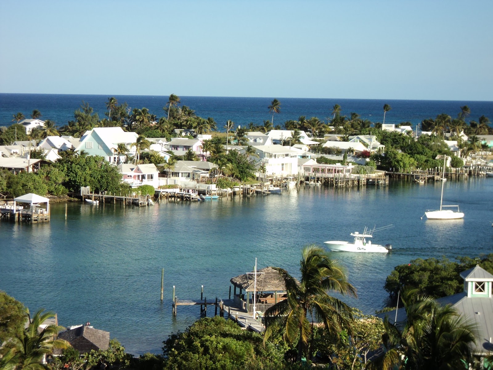
We spent this past week sailing around the hub of the Sea of Abaco visiting many of the islands. Marsh Harbor is the largest town in the Abacos we visited, with a population of 5,300. It is big enough to warrant a stop light and all the noise, commotion and traffic that goes with it.

Marsh Harbor
Government Complex
 
But, the benefits of Marsh Harbor include the largest grocery store in the Abacos. This means a greater variety of food, but not necessarily cheaper prices.  For example, milk costs $4.83 a gallon, cereal $6.00 - 9.00 a box, yogurt $1.50 for 6 oz, cheese $8.00 per pound, sliced turkey $12.00 per pound, and the most shocking was paper towels at $29.70 for 8 rolls!  On some of the other islands we visited, apples were going for $2.00 each and bread for $6.00 per loaf.  So while everything here is very expensive, we can't complain to much because the beaches and the people make it all worthwhile! We spent two days in Marsh Harbor doing laundry, going to the bank, filling prescriptions, mailing letters and going to the hardware store.


Man-O-War Cay
"Little Lara" is moored
right about there ...
Soon we had all our errands completed and we were off to Man-O-War Cay. This tiny island of about 300 people is 2.5 miles long and lies just four miles from Marsh Harbor. It is known for its boat building history, which dates back hundreds of years. We enjoyed the canvas shop, woodcarving store, narrow streets, well manicured lawns and the marvelous beaches. We found the people to be very conservative, very religious and very friendly.  There are few restaurants here, but there are four churches.


"The Low Place", Man-O-War Cay
Note, the Sea of Abaco is to the left and the Atlantic Ocean is to the right

Lots of work to get this coconut opened!


Knowing that there was nasty weather coming, we decided to leave Man-O-War Cay and sail four
miles to Hope Town on Elbow Cay. Elbow Cay is another one of the many small cays in the dog-legged-shaped barrier islands near the mainland of Great Abaco Island. At around 4.5 miles long and 1,100 yards wide, Elbow Cay is home to wonderful people, great food, beautiful beaches, coconuts, breathtaking sunsets, and an amazing light house. The famous Elbow Reef Lighthouse is probably the most recognizable landmark in all of the Abacos.  It is one of the last manual lighthouses in the
world.  The lamp burns pressurized kerosene oil with a wick and mantle.  The Fresnel lenses concentrate the mantle’s light into a beam directed straight towards the horizon.  The lenses and burner equipment, weighing 8,000 lbs, float in a circular lubricated tub.  This reduces friction so that the 700 lbs of weight, when wound up to the top of the tower by hand, smoothly rotates the 4-ton apparatus once every 15 seconds.  The lighthouse keeper on duty must wind up the weights every 2 hours in order for the red and white candy-striped lighthouse to be seen from 17 miles away.

Hope Town Harbor


Streets of Hope Town

In  1863, England decided, to build a lighthouse at Hope Town to steer ships clear of the extensive “Elbow Reef”.  Despite protests made by wreckers (salvagers), the lighthouse was completed in
Elbow Cay Lighthouse
1864.   In 1996, for economic reasons, the Port Department was prompted to automate the hand-wound kerosene–burning lighthouse in the Bahamas.  The Lighthouse Preservation Society (the non-profit historical and educational society dedicated to its preservation) convinced the government to reconsider, as long as the Society would provide the Port Department with the parts they needed that were no longer available through their previous supplier.  Since then, the Society has been using mantles from the Coleman Company (manufacturer of Outdoor Equipment).  Today, the Elbow Reef Lighthouse is still sending out light, rated at 325,000 candlepower, with the same light source it acquired in 1863.  As we waited for the weather to improve, we enjoyed seeing the lighthouse lit up for the Christmas season with Christmas lights and its bright, rotating "star" on top.

Attending Church Meetings at "Summer Magic"
 
We loved walking through Hope Town, admiring the beautiful flowers, narrow streets and quaint homes. We noticed that the houses in Hope Town do not have street addresses, but names, like boats. We attended LDS Church in Hope Town, in the beautiful home of Chris and Lisa. They were kind enough to invite us to worship with them. We truly appreciated being able to attend Sacrament Meeting with them.  We loved everything about Hope Town.  Thus far Hope Town is "Da Bes Yet, Mon".

Who is at the helm?


"Where to now, babe?"

Fair Winds


Sunday, December 4, 2016

Dat Way To Da Beach, Mon

"Beach Dat Way"


We only spent at day at Spanish Cay before pushing off for Green Turtle Cay.  We motored most of
New Plymouth, Green Turtle Cay
the way due to light winds, but fortunately this harbor is a mere 16 miles away from Spanish Cay.  We were particularly interested in going to Green Turtle Cay because we stopped there in 2001 with our children.  We took a mooring ball in Black Sound, provided by Donny's Marina.  We were surprised at how much the island had changed and how much it remained the same.  The town, New Plymouth, is bigger now, and they have cell service, but the same Easter-egg-colored houses, post office and narrow streets still exist.  

 
Relaxing at the New Plymouth
Post Office

There are more cars and trucks on the island now, but the locals still prefer to drive golf carts around town.  We found the people to be very friendly, offering us golf cart rides into town and making sure all our needs were met.  Donny was exceptionally nice, answering our many questions and recommending sites to visit around the island.   We remained at Green Turtle Cay five days attending community events, visiting the museum and meeting the locals while waiting to round Whale Cay.


Rounding Whale Cay

Whale Cay has a reputation of being the most difficult and treacherous passage in the Abacos.  In certain weather conditions it is impossible to traverse this area.  This is because a shallow bank extends out from this small island, and when the wind is blowing out of the north the waves kick-up a "raging sea".  On these days it is impossible to get around the island.  When we made the passage, however, the wind was out of the South and the waves were fairly calm.


Leah at Baker's Bay in 2001
Once around Whale Cay we stopped at Baker's Bay to celebrate our passage and enjoy brunch.  Baker's Bay is another area that held fond memories for us and our 2001 trip, but this is one of those areas that had changed drastically,  almost to the point of non-recognition. In 2001 this was an abandoned cruise ship destination: Treasure Islands.  Our children enjoyed playing on the beach and exploring the ruins -- tiki huts, amphitheater, empty shops, etc.  Today the beach is restricted and high-end homes have replaced the ruins.  Somethings never change, while others change so much they will never be the same.  Time marches on!


Exploring Treasure Islands Ruins in 2001

Until next time, Fair winds.

Sand Dollar Beach, Green Turtle Cay